 PLN
PLN BRL
BRL CZK
CZK EUR
EUR EUR
EUR EUR
EUR EUR
EUR GBP
GBP RUB
RUB SEK
SEK USD
USD
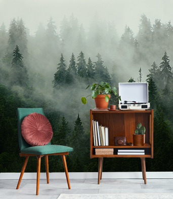


Fototapet i vinyl
Fototapet i vinyl som är tryckt på ett hållbart underlag och med en slät och matt yta. Tapetens färger kommer att vara klara under flera år framåt tack vare HP Latex bläcket.
- ✓ Resistent mot deformation och töjning
- ✓ Släpper igenom vattenånga
- ✓ Enkel montering
- ✓ Ekologiskt HP latex bläck
Blockets maximala bredd: 95-105 cm. Om storleken överstiger den maximala bredden av materialet , kommer utskriften att bestå av flera jämna ark
Användning: släta och jämna väggar.
Limmetod: Limmet appliceras endast på väggytan och vi lägger nästa block kant mot kant, vilket minskar risken för skador på tapeten och underlättar små korrigeringar av dess läge
Rengöringsmetod: torr trasa
Halvmatt: finish

Fototapet i vinyl som är tvättbar
Tvättbar fototapet i vinyl är tryckt på ett slitstarkt underlag med en slät, matt yta och täcks sedan med laminat, som skyddar mot fukt och negativ påverkan från andra yttre faktorer (repor, skador, solljus). Den moderna HP Latex-trycktekniken möjliggör livliga färger under lång tid.
- ✓ Täckt av laminat
- ✓ Beständig mot fukt, repor, nötningar och soleffekt.
- ✓ Resistent mot deformation och töjning
- ✓ Släpper igenom vattenånga
- ✓ Enkel montering
- ✓ Ekologiskt HP latex bläck
Blockets maximala bredd: 95-105 cm. Om storleken överstiger den maximala bredden av materialet , kommer utskriften att bestå av flera jämna ark
Användning: släta och jämna väggar. Utrymmen som är mycket fuktiga (kök, badrum) samt utrymmen som riskerar att få repskador (hallen, barnrummet, hotell, restaurang, konferenssal, allmänna byggnader, skolor, dagis)
Limmetod: Limmet appliceras endast på väggytan och vi lägger nästa block kant mot kant, vilket minskar risken för skador på tapeten under renoveringsarbeten och underlättar små korrigeringar av dess läge
Rengöringsmetod: våt trasa
Halvmatt: finish
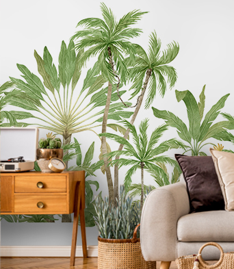
Strukturell fototapet i vinyl
Strukturell fototapet i vinyl är tryckt på ett hållbart underlag med en struktur baserad på finkornig sand . En sådan finish gör det möjligt att få ett intensifierat intryck av tryckets djup. Med HP latex teknik så kan du behålla uttrycksfulla färger i många år.
- ✓ Finkornig sandstruktur
- ✓ Resistent mot deformation och töjning
- ✓ Släpper igenom vattenånga
- ✓ Enkel montering
- ✓ Ekologiskt HP latex bläck
Blockets maximala bredd: 100 cm. Om storleken överstiger den maximala bredden av materialet , kommer utskriften att bestå av flera jämna ark
Användning: släta och jämna väggar. Fototapeten kommer att vara utmärkt i såväl bostadsinteriörer samt i restauranger kontor och skolor
Limmetod: Limmet appliceras endast på väggytan och vi lägger nästa block kant mot kant, vilket minskar risken för skador på tapeten och underlättar små korrigeringar av dess läge
Rengöringsmetod: torr trasa
Finish: halvmatt, finkornig struktur

Strukturell fototapet i vinyl som är tvättbar
Fototapet i vinyl är tryckt på ett fast underlag med samma struktur som fin sand som ser till att man uppnår en förhöjd känsla av tryckets djup. Med HP latex teknik så kan du behålla uttrycksfulla färger i många år.
- ✓ Täckt av laminat
- ✓ Finkornig sandstruktur
- ✓ Beständig mot fukt, repor, nötningar och soleffekt.
- ✓ Resistent mot deformation och töjning
- ✓ Släpper igenom vattenånga
- ✓ Enkel montering
- ✓ Ekologiskt HP latex bläck
Blockets maximala bredd: 100 cm. Om storleken överstiger den maximala bredden av materialet , kommer utskriften att bestå av flera jämna ark
Användning: släta och jämna väggar. Dekorationer av utrymmen som är mycket fuktiga (kök, badrum) samt utrymmen som riskerar att få repskador (hallen, barnrummet, hotell, restaurang, konferenssal, allmänna byggnader, skolor, dagis)
Limmetod: Limmet appliceras endast på väggytan, vilket minskar risken för skador på tapeten under renoveringsarbeten och underlättar små korrigeringar av dess läge
Rengöringssätt: med en fuktig trasa
Finish: halvmatt, finkornig struktur

Självhäftande fototapet
Tack vare en universell tillämpning så kommer den passa utmärkt i olika utrymmen och på olika ytor, Självhäftande fototapeter kommer att passa utmärkt när de är fastlimmade på väggen, på skåp, glas, möbler och andra släta ytor. Uttrycksfulla och levande färger tillhandahålls av HP Latex många år framåt.
- ✓ Utan något ytterligare lim
- ✓ Väldigt enkel och snabb montering
- ✓ Resistent mot deformation och töjning
- ✓ Släpper igenom vattenånga
- ✓ Ekologiskt HP latex bläck
Blockets maximala bredd: 133 cm
Tillämpning: släta ytor, universell tillämpning
Limmetod: kant mot kant
Rengöringsmetod: våt trasa
Halvmatt: finish


